 Protected bicycle lanes
 Protected bicycle lanes
Nearly 9% of all trips and over 13% of commute trips in Vancouver are by bike, exceeding the City’s 2020 target of 7% and on track to achieve the 2040 target of 12%.
To help build on this shift, we have made cycling a much safer and more attractive option, by adding protected bike lanes to key city streets.
Protected bicycle lanes are dedicated bike lanes with concrete medians and planters, bicycle parking corrals, or vehicle parking lanes that divide them from vehicle traffic.
This separation increases feelings of safety and comfort, which makes cycling an attractive commuting option for those who are not used to riding their bikes regularly.
When people walking know that people won't be riding their bikes on the sidewalks, walking feels more comfortable, as well.
We have protected bike lanes on many downtown streets, including Beatty Street, Burrard Bridge, Carrall Street, Comox/Helmcken Street, Dunsmuir Street, Dunsmuir Viaduct, Hornby Street, Richards Street, and Smithe Street.
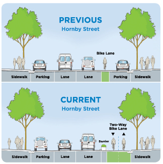 This drawing shows the difference between the previously painted bike lane and the current protected bike lanes on Hornby Street.
On streets such as Hornby and Dunsmuir streets, protected bike lanes provide two-way travel for people cycling on the same side. This can create the need for additional traffic signals for both cycling and walking traffic.
On streets such as Burrard Street (Drake to W 1st Avenue southbound and W 1st Avenue to Pacific Street northbound), the protected bike lanes are one-way on one or two sides of the street. Please ride safely, and ensure you are riding the right way in a one-way bike lane.
We collect statistics about total monthly trips and mid-week daily trips for the following protected bike routes:
If you ride your bike into or out of Vancouver, look into the maps maintained by TransLink, the regional transportation agency that operates Vancouver's transit system.

Cycling signs and road markings are described, along with tips, regulations, and routes, in our downloadable cycling map.
Download the cycling mapRead our 2019 edition: