We are planning for 50cm of sea level rise by mid-century, 1m by 2100, and 2m by 2200.
Parts of Vancouver within low lying areas close to the ocean and Fraser River are vulnerable to coastal and river flooding.
Climate change will increase our vulnerability to flooding due to rising sea levels.
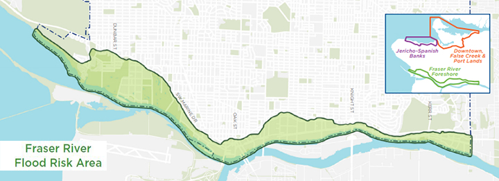
The Fraser River Foreshore is the most at risk to flooding.
We've developed a Coastal Adaptation Plan (CAP) that captures the values and guiding principles that we heard during engagement with Fraser River foreshore communities, Musqueam First Nation, and businesses. We're currently doing technical feasibility analysis of a range of possible coastal adaptation options.
A new phase of public engagement is expected to start in 2026.
Phase 1: Engagement
We're reaching out to the Fraser River Foreshore communities, Musqueam First Nation, and businesses to build awareness and identify actions to become more resilient in the face of coming challenges.
The feedback we receive on values, guiding principles, and potential flood management options will help develop criteria to use when we evaluate potential flood management strategies for the area.
Documents
Fraser River flood risk area
The Fraser River shoreline stretches 16 kilometres along Vancouver's southern border. It is a diverse area with residential neighbourhoods, Musqueam First Nation, businesses, industry, recreation areas, and foreshore habitat areas.
Without improvements, a major flood event could impact 280 commercial and industrial buildings, damage over 400 homes, and generate over $300 million in financial losses in today's dollars.
Vancouver's three primary flood zones:
- The Fraser River foreshore
- Jericho Spanish Banks
- Downtown, False Creek, and the Port Lands