

On July 10, 2024, City Council approved the replacement of the View Protection Guidelines with new Public Views Guidelines PDF file (217 KB), including amendments to some of the public views.
Based on the amended view cones, you can request a public view assessment.
Vancouver is known around the world as a modern, cosmopolitan city set against the spectacular backdrop of the North Shore Mountains. These views remind us of our connection to nature and, together with select views to important landmark buildings, reinforce our unique civic identity.
Since 1989, Vancouver has maintained a series of Council-approved protected public views to shape development in the city's downtown and central neighbourhoods. It does this in a way that balances the need for economic growth and housing while also preserving landmark views for future generations.
Although the views have shifted over time to respond to the changing urban context, protecting important views from accessible public places remains a fundamental part of Vancouver's approach to city building.
What's happeningHelp shape Trout Lake public views
We’re looking for feedback on proposed changes to the public views from the south shore beach at Trout Lake.
Following Council's direction and the Province’s Transit-Oriented Area (TOA) legislation, these changes seek to find the balance between maintaining mountain views from the beach and the need for more housing near rapid transit.
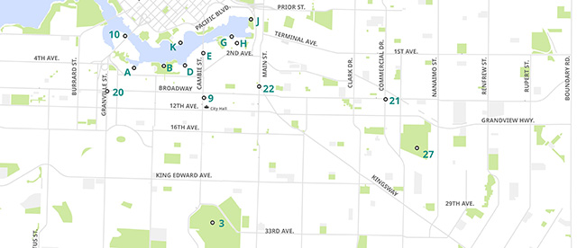
Public view origin points
In consultations with the community, we have identified several locations from which both residents and visitors can appreciate views of the North Shore mountains, the Downtown skyline, and the surrounding water.
Granville Bridge (view 12) has been removed. Review the Granville Street Plan for more details PDF file (27 MB)
Where to find public view corridors
On this map, the numbers and letters indicate locations where you can see the view corridors.
Information icon Select image to review a larger version of the map.
Higher Building Policy
At some strategic locations in downtown, buildings may be permitted to enter into the view cone boundaries of the Queen Elizabeth Park public views, and others identified in other policy documents. These are referred to as 'Higher Buildings' sites and are subject to a special review process.

