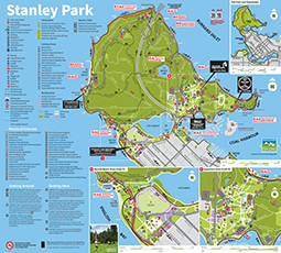
Download a printable map of Stanley Park

Download a Stanley Park map

Have a look at our maps, and pick one based on what you want to do during your visit to Stanley Park.

Printable map of services in Stanley Park

Use this map to help you find points of interest, washrooms, food, phones, and parking.

Download a printable map (6.4 MB) that fits on a 8½×11-inch sheet of paper.

Download a copy of the services map for Stanley Park

Stanley Park official map and guide

A detailed map of Stanley Park includes landmarks, monuments, walking, cycling, and wheelchair trails, washrooms, shuttle bus stops, concessions, businesses, cultural attractions, and more.

Pick up the free map and guide at the Information Booth in the park, and at Park Board facilities such as community centres, and City golf courses. They are also available at key tourist locations — Peace Arch border crossing, the airport, BC Ferries, major Vancouver hotels, car rental offices and the Tourism Vancouver Visitor Centre.

Download the map and guide (2.5 MB)

For a more detailed picture of Stanley Park, click on the image on the left to download the official map and guide to Stanley Park.

Map of Stanley Park trails

Explore Stanley Park's seaside and forest trails by foot or by bike.

Download a map of trails in Stanley Park (339 KB).

Map of Stanley Park Trails

Tour the park

Join a guided tour and see Stanley Park by horse-drawn carriage, shuttle trolley, or tour bus. Or explore the park on your own.

Digital map

Stanley Park is located in downtown Vancouver. Check out this digital map to plan your visit or route.

Trails

Explore more than 27 km of forest trails, winding through the Stanley Park's dense foliage.