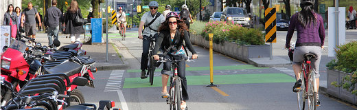
We are building and expanding Vancouver's cycling network with low-stress, high quality routes that are:
Safe and comfortable—regardless of your age and ability
Convenient, connecting you to destinations such as schools, community centres, transit stations, and shopping and employment areas
More equitable, by improving connections to underserved areas and populations
Guided by Transportation 2040, we will consult on and implement 5-year plans that prioritize:
Creating routes with the highest existing or potential demand
Closing critical gaps and making spot improvements
Making high collision areas safer
Connecting key destinations
2023 to 2027 Active Mobility Plan
Our 2023 to 2027 Active Mobility Plan (AMP) outlines upcoming infrastructure projects to advance our active transportation network.
It supports city goals related to health, safety, equity, accessibility, affordability and complete communities. It also supports the Climate Emergency Action Plan target (CEAP) of two-thirds of all trips by active transportation and transit by 2030.
The AMP includes maps for major corridor projects and walking programs.
Major walking and public realm improvements: These are typically busy walking corridors such as retail streets, where street space reallocation for walking and public realm improvement is envisioned. These were identified from Transportation 2040, VanPlan, and council motions.
Complete streets: These are busy major streets where high-quality facilities for all modes of transportation are to be planned. For active travel modes, this typically includes sidewalks buffered from traffic as well as protected bike lanes.
Greenways: These are predominantly local streets that are envisioned to be traffic calmed for an enhanced walking, biking, rolling, and public space experience. They can include portions of off-street pathways or protected bike lanes to bridge gaps along short segments of busier streets.
These projects will be delivered based on funding and resource availability. Implementation of some projects will extend beyond 2027. Complex projects will require further planning, design and Council approval. Other active transportation projects may be delivered in the near term, through coordination with development and other capital work.
An updated version of the plan will be released every few years to reflect new priorities.
The walking priority areas map PDF file (3 MB) identifies areas where enhanced walking infrastructure can have the most benefits to as many residents as possible, including for those who have historically been underserved.
Priority areas are based on access to everyday destinations, high population density, close proximity to rapid and frequent transit, and equity.
Vancouver ranks highest among Metro Vancouver municipalities in terms of complete sidewalk coverage (with sidewalks on both sides of the street), but we’re still missing 450 km of sidewalks. Currently, the sidewalk network is 80% complete.
The sidewalk priorities map PDF file (2 MB) identifies critical gaps in our sidewalk network. These projects will be delivered based on funding availability. Other sidewalks may be constructed or improved through coordination with development and other capital work.
Curb ramps on street corners provide improved access for people using strollers, wheelchairs, walkers, canes; and other mobility aids.
The curb ramp priorities map PDF file (3 MB) identifies high priority locations with missing curb ramps, particularly those with close proximity to critical destinations such as senior centres, hospitals, community centres, rapid transit, and high walking priority areas.
Designing cycling routes
Read our 10 general rules that we consider when building cycling routes for people of all ages and abilities (AAA).