

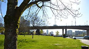
The False Creek North Walk is 2.4 km, and approximately 3,202 steps. It covers nearly the entire stretch of the north side of the inlet. Traveling along the seawall, the route passes beneath all three bridges and through several of downtown Vancouver’s carefully developed waterfront communities.
Route statistics
| Distance | 2.44 km |
| Steps | 3,202 |
| Elevation change | 9 m |
Route description
The north side of False Creek, once home to Expo 86, is divided into several neighbourhoods with each precinct centered on a bay and separated by a public park. The areas have been designed by different teams and constructed with unique materials to provide a distinct feeling.
As you walk along the route notice the changes in colour and design. The starting point for the walk beneath the Cambie Street Bridge at Cooper's Park is within the Quayside neighbourhood. This area is mainly white and very striking. Travel west along the seawall to Marinaside Crescent you will find the pathway is paved with brick, divided for walkers and cyclists, and lit by oversized lampposts.
The walkway is at a lower level than, or entirely away from the street and offers seclusion from vehicle traffic. The small bays along this walk have marinas with many moored yachts, and ferry docks which have small pedestrian ferries shuttling commuters to and from various points along False Creek.
Accessibility
This route is made up of paved walking and cycling paths with only a small incline.
For those with limited mobility an alternate path is available to bypass a set of stairs under the Burrard Street Bridge. Follow the route markers along the seawall to bypass these stairs.
 This site was once home to the Sweeney Cooperage, the largest barrel manufacturer in the British Empire from 1889 until 1980. Barrels made here traveled all over the world carrying goods such as strawberries and other soft fruits in diminutive one quart sizes up to traditional larger (800 lb) casks for whiskey, beer and salt-cured salmon. The sawmill which produced the wooden barrel parts was built in 1945 and overlooked False Creek at this location. The cooperage closed in 1981 to make way for the construction of B.C. Place and the new Cambie Street Bridge.
 Time Top - Jerry Pethick
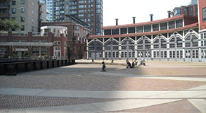 The Roundhouse
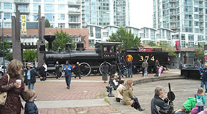 Engine No. 374
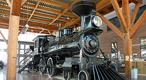 374 Pavilion
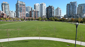 This park was named in 1995 for British Columbia Lt. Governor David Lam. It was the site of Live City Yaletown during the 2010 Winter Olympic Games, and is a vast green space 4.34 hectares in size. David Lam Park offers several facilities including: basketball and tennis courts, soccer fields, playgrounds, and washrooms. It is a great place to fly a kite, toss a Frisbee, or rest in the sunshine. The park is sheltered by beautiful plantings and home to several intriguing sculptures.
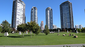 This park opened in 2004, and is named to honour Vancouver's longest serving Park Board Commissioner. George Wainborn contributed to the City's parks and recreation system for 33 years between 1956 and 1990. Occupying a significant portion of the waterfront, the park is comprised of 2.5 hectares of formal and informal spaces. It has an expansive lawn, dramatic water feature and several art installations.
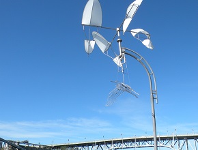 Khenko